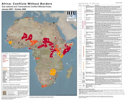
Whenever Patrick Meier and I get together, we're sure to spend at least some of that time grousing over the fact that static maps in services like ReliefWeb are frustrating. Below is an excellent static map showing cross-boarder conflict in Africa, and an excerpt from Patrick's blog on it.

 I'm open for ideas on this, and would love to see someone create a service that could be used by others too. For instance, I'd like to see a tool that we could plugin to Ushahidi, or use in conjunction in some way, that would allow the data to be analyzed in different ways and by different types of people.
Thoughts?

"Instead of the usual depiction of conflicts as countrywide and defined by national boundaries, this map displays distinct conflict-affected areas in Africa as sub-national and transnational pockets of insecurity, violence, and armed aggression. Areas of conflict were drawn around locations of reported conflict incidents in 2007 and 2008, as well as concentrations of internally displaced persons and cross-border rebel bases and refugee camps in neighboring countries."
Usefulness, Usability and Utility
It seems there is so much useful information tied up in formats that aren't re-usable by others. What if I wanted to take that same data from the cross-border conflict map above and overlay it with information on colonial land redistribution to see if there was a correlation. I can't, or it's not very easy. However, we come smack up against a usability problem. For non-technical users, right now it's a lot easier to deal with maps in a PDF or JPG form. There is no need to understand the tech gibberish that is constantly spouted off by those of us on the tech side of the table. So, it's not perfect, but work gets done.Is There a Happy Medium?
I don't know if there is a simple enough implementation of new dynamic mapping that would allow anyone to easily mashup multiple bits of information. The closest so far is what GeoCommons is doing with Maker and Finder. It's easier, but I'm not sure if even that is the answer quite yet. I'm open for ideas on this, and would love to see someone create a service that could be used by others too. For instance, I'd like to see a tool that we could plugin to Ushahidi, or use in conjunction in some way, that would allow the data to be analyzed in different ways and by different types of people.
Thoughts?